


CHINASE | ENGLISH
bottom
 DOWNLOAD
 E-MAIL

NEWS
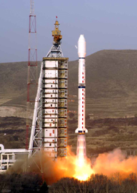
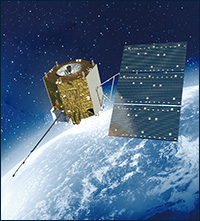
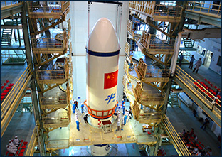
Long March 2D was successfully launched with Siwei Gaojing-3 01 satellite
At 12:12 on April 15, 2024, Long March 2D launch vehicle was successfully launched from Jiuquan Satellite Launch Center, and successfully placed Siwei Gaojing-3 01 satellite into its destination orbit, signaling a complete success of the launch mission. Both the satellite and the launch vehicle are developed by Shanghai Academy of Spaceflight Technology.
The Long March 2D launch vehicle for this launch mission is a level 2 carrier rocket with liquid propellant of normal temperature. It has a takeoff thrust of about 300 tons, and a payload capacity of 1.3 tons for deploying satellites into a 700-kilometer sun-synchronous orbit, as well as the single-satellite and multiple-satellite launching capabilities meeting the requirements of different orbits.
In this mission, Long March 2D launch vehicle adopts new ground checking and launching software. To ensure the successful completion of the launch mission, the model team established a checking and launching software group responsible for server deployment, debugging, and mission assurance. They conducted thorough technical exchanges with the launch site, and prepared new instructions and operating procedures according to the characteristics of the checking and launching software.

Given the frequent occurrence of harsh weather conditions like strong winds and dust at Jiuquan Satellite Launch Center in March and April, the test team developed procedures for the launch site work in advance, and adjusted in real-time the range transfer time of the first and second stage rockets and the fairing assembly based on the meteorological data provided by Jiuquan Satellite Launch Center, effectively ensuring the smooth progress of the mission as planned.

This mission marks the 88th launch of Long March 2D launch vehicle, the 207th launch of the Long March series of launch vehicles developed by Shanghai Academy of Spaceflight Technology, and the 516th launch of Long March series of launch vehicles.

Satellite test team
Making solid progress in the development of commercial satellites
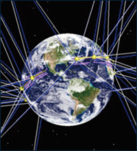
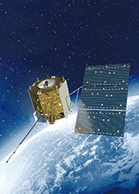
Siwei Gaojing-3 01 satellite is a commercial optical satellite developed by SAST, serving as an important component of China’s Siwei commercial remote sensing constellation project. The successful launch of the satellite marks a solid step forward made by SAST in the field of commercial satellite development, demonstrating SAST’s commitment to actively respond to the national call for developing the commercial space industry and fostering new quality productive force. Once the satellite is networked with other Gaojing series of satellites, it will possess the comprehensive application capabilities characterized by high resolution and wide swath, multiple functions, hour-based response, and week-based coverage, thus meeting the requirements of various industries such as national land management, mapping, marine surveillance, environmental protection, earthquake monitoring, and emergency response for high spatial resolution data.

Siwei Gaojing-3 01 satellite operates in a 500-kilometer sun-synchronous orbit, and is equipped with a large-aperture wide-field off-axis three-lens reflex visible-light camera. Compared to other high-resolution commercial remote sensing satellites at home and abroad with swath widths of 10 to 20 km, this satellite shows significantly improved performance. It is China’s first commercial optical remote sensing satellite to possess an ultra-large swath width of over 130 km that can provide imagery data with a resolution of 0.5 meters and a combination of nine bands. The satellite innovatively adopts the high-density compression storage technology, onboard autonomous intelligence technology, high-speed high-order phased array transmission technology, high-performance multispectral integrated detector technology, high-precision uncontrolled positioning technology, etc. It is characterized by its intelligence, flexibility, superior performance, and high reliability, with its technological capabilities at the forefront domestically and advanced globally in the commercial remote sensing field.
After the satellite is in orbit, it can comprehensively use the high-resolution wide-angle imaging technique to capture high-resolution image data over large areas globally. Compared to conventional high-resolution commercial remote sensing satellites, the width has been increased by more than five times. The satellite has nine bands. In addition to the common full-color, red, green, blue, and near-infrared bands, it has another four new bands including coastal aerosol, yellow, red edge, and near-infrared 2. These bands can be used for various quantitative purposes such as cloud and haze removal, forest land classification, and vegetation monitoring. The produced data products will effectively support our applications in fields such as national land resource survey, urban management, environmental protection, disaster prevention and reduction, and maritime safety. At the same time, based on massive high-performance base image data, there will also be broad application prospects in emerging markets such as digital agriculture, smart water management, and digital cities through the in-depth development of value-added products and information products.
The team of Siwei Gaojing-3 01 satellite has pioneered a new model for commercial satellite development, opening up a new direction for the development of commercial remote sensing satellites. To accelerate the formation of new quality productive force in the commercial space industry, the team innovatively adopts a research and development management model adaptable to commercial projects. By establishing positions such as project manager and technical manager, it has effectively coordinated resources. By replacing serial development with parallel iterative development, the whole satellite AIT time has been reduced by 30%. Through collaborations with universities, research institutes, and innovative enterprises, the team has actively promoted technological and management innovation. By comparing with commercial remote sensing satellites at home and abroad, it has not only achieved the performance of high resolution and wide swath, but also realized cost-effectiveness and short development cycles.