


CHINASE | ENGLISH
bottom
 DOWNLOAD
 E-MAIL

NEWS
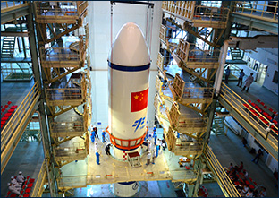
Fengyun Meteorological Satellites Contributing Chinese Wisdom to Global Disaster Prevention and Mitigation
Recently, the People’s Daily published an article titled Fengyun Meteorological Satellites Contributing Chinese Wisdom to Global Disaster Prevention and Mitigation, which introduces the outstanding contributions made by Fengyun series meteorological satellites developed by Shanghai Academy of Spaceflight Technology in global disaster prevention and mitigation and the building of a community with a shared future for mankind.
In the vast expanse of space, there are countless twinkling stars. Among China’s numerous artificial satellites orbiting the Earth, Fengyun meteorological satellites are acclaimed as the “satellites closest to the people’s daily lives”. These satellites monitor the weather changes around the clock, observe global meteorological conditions constantly, and provide daily weather forecasts.

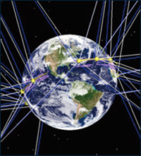
▲ In-orbit operation diagram of Fengyun meteorological satellites
After years of development, Fengyun meteorological satellites have been widely used in multiple fields such as weather forecasting, climate prediction, natural disaster and environmental monitoring, and scientific research, and in many industries such as the meteorology, oceanography, agriculture, forestry, water conservancy, transportation, aviation, and aerospace industries, making significant contributions to disaster prevention and mitigation, combating climate change, and promoting sustainable economic and social development.
From “capturing images” of the atmosphere to “performing CT scans” of the atmosphere, Fengyun meteorological satellites have achieved a remarkable transition from following international standards to keeping space and even leading the pack in some areas, significantly improving China’s capabilities in meteorological monitoring, forecasting, and early warning. Fengyun meteorological satellites provide services for the “Belt and Road Initiative”, and also contributes Chinese wisdom to global disaster prevention and mitigation, which embodies China’s sense of responsibilities in the world.

In-orbit deployment of multiple satellites and networked observation, making it the mainstay of the global Earth observation network
In July 2023, after the formation of Typhoon Doksuri, No. 5 over the northwestern Pacific Ocean, Fengyun meteorological satellites began monitoring the typhoon throughout its entire lifecycle, which provided services for the decision-making in special consultations about Typhoon Doksuri and heavy rainfall, and also offered strong support for accurately monitoring the extreme heavy rainfall weather caused by Doksuri.
Fengyun meteorological satellites constitute a series of meteorological remote sensing satellites independently developed by China. In 1988, China successfully launched its first meteorological satellite. So far, China has successfully launched a total of 21 Fengyun meteorological satellites, including four types across two generations. Currently, there are 9 satellites in orbit, providing data and products to 129 countries and regions. Currently, China is the only country in the world operating four near-earth orbit meteorological satellites simultaneously in the dawn, morning, afternoon, and inclined orbits. Through in-orbit deployment of multiple satellites and networked observation, Fengyun meteorological satellites can provide precise 3D, quantitative, global, round-the-clock, all-weather, and hyperspectral monitoring data with high time efficiency.

▲ Operational orbit of Fengyun-3 series satellites
|
上午轨道气象卫星 |
Morning orbit meteorological satellite |
|
晨昏轨道气象卫星 |
Dawn-dusk orbit meteorological satellite |
|
低倾角轨道气象卫星 |
Low-inclination orbit meteorological satellite |
|
下午轨道气象卫星 |
Afternoon orbit meteorological satellite |
Fengyun meteorological satellites boast exceptional performance and are capable of precisely monitoring various weather and climate events, achieving unparalleled detection of typhoons, conducting three-dimensional “CT” scans of heavy rainfall, and accumulating climate variable data on El Niño events. They also provide outstanding services for the “Belt and Road Initiative”. Therefore, they have become the mainstay of the global Earth observation network.
“Meteorological satellite monitoring has played a significant role in short and near-term forecasting,” said Li Jun, the chief scientist of the National Satellite Meteorological Center. Taking severe convective weather as an example, it has a relatively short lifespan and is characterized by its sudden onset, thus posing greater challenges in monitoring and forecasting. Meteorological satellites have a wide observation range and fewer interference factors, so it can precisely capture the traces of severe convection weather, thereby assisting in monitoring and forecasting severe convection weather events.

▲ At 16:35 on May 7, 2023, the precipitation radar onboard Fengyun-3G satellite detected rainfall near Hainan Province and Yangjiang City in Guangdong Province. The above image shows the 3D structure of the precipitation system from 3.75 km of the surface to 6 km.
Niels Bormann, a Principal Scientist of the European Centre for Medium-Range Weather Forecasts, said that in recent years, data obtained from the instruments carried by Fengyun meteorological satellites has been playing an increasingly important role in the assimilation of numerical weather prediction models at the European Centre for Medium-Range Weather Forecasts.
“By combining satellite observation data with ground observation data, we can better monitor meteorological disasters and their impacts on agriculture,” said Fang Shibo, a researcher at the Chinese Academy of Meteorological Sciences.
“In the past few years, we used the remote sensing technology of Fengyun meteorological satellites to monitor the extreme drought events in Central Asia, and assist in researching the causes of drought, climate changes, and their impacts. After identifying the affected areas, we helped them reduce adverse impacts and enhance climate resilience,” said Sanjarbek Muratov, the representative of the Food and Agriculture Organization of the United Nations in Uzbekistan.
Offering emergency support services to users worldwide, reaching 34 countries
On November 13 last year, the international version of “Fengyun Earth” was officially launched. It is an integrated application platform for satellite remote sensing specially developed for international users by China Meteorological Administration based on the “Fengyun Earth” platform relying on Fengyun meteorological satellites and satellite remote sensing technology.

▲ International version of “Fengyun Earth”
It is described that the international version of “Fengyun Earth” exhibits excellent performance. On one hand, it can acquire data from multiple sources such as meteorological satellites and numerical forecasts with high time efficiency, and quickly produce quantitative products. While acquiring massive data, it can utilize advanced AI technology for automatic data analysis, data mining, and modeling, thus intelligently identifying disastrous weather and extreme climate events. On the other hand, it can provide over 100 quantitative, multidimensional products categorized into five major types, including cloud pictures, elements, disaster events, climate, and model verification, supporting various business scenarios. It can also configure meteorological elements, observation areas, time ranges, etc. with special focus for different countries and regions to meet users’ personalized requirements.
The international version of “Fengyun Earth” has received a task soon after its launch, namely, to provide event security services for the 17th Pacific Games held in the Solomon Islands. In response to the invitation from the Solomon Islands Meteorological Services, China Meteorological Administration activated the rapid scanning observation mode of Fengyun-4B satellite centered around the Solomon Islands while sending experts there, providing dozens of satellite products based on the international version of “Fengyun Earth”, which offered crucial support for the successful hosting of the Pacific Games.
To provide services to international users, China Meteorological Administration established a dedicated emergency support mechanism for disaster prevention and mitigation for international users based on Fengyun meteorological satellites in April 2018. By 2023, a total of 34 countries had registered to join this emergency support mechanism.

▲In March 2019, countries including Mozambique were affected by the tropical cyclone “IDAI”, resulting in serious flooding. Fengyun meteorological satellites provided services promptly to Mozambique and other affected countries.
|
FY-3D气象卫星监测图像 |
Monitoring image of FY-3D meteorological satellite |
|
2019年3月14日18:50(北京时间) |
18:50, March 14, 2019 (Beijing time) |
|
坦桑尼亚 |
Tanzania |
|
印度洋 |
Indian Ocean |
|
马拉维 |
Malawi |
|
莫桑比克 |
Mozambique |
|
津巴布韦 |
Zimbabwe |
|
西南印度洋热带气旋“伊代”-IDAI |
The tropical cyclone “IDAI” in the South-West Indian Ocean |
|
中国气象局国家卫星气象中心 |
National Satellite Meteorological Center, China Meteorological Administration |
Since 2023, Fengyun meteorological satellites have responded to international emergency support services requests 28 times. For example, they observed tropical cyclones Lola and Mocha, providing meteorological support services to countries such as the Solomon Islands, Vanuatu, and Bangladesh; they also helped to monitor the intensive fire points from the northern coastal areas of Algeria to the northwest of Tunisia, providing assistance to the local fire prevention and control work.

▲ Due to persistent extreme high temperatures and drought, on July 24, 2023 local time, the monitoring result of Fengyun meteorological satellites showed that there were forest fires in northern Algeria and some areas of Tunisia, with volcanic smoke and dust spreading towards the Mediterranean Sea.
|
气象卫星全球火点图 |
Global fire point map from meteorological satellite |
|
2023年07月24日 |
July 24, 2023 |
|
瑞士 |
Switzerland |
|
奥地利 |
Austria |
|
法国 |
French |
|
波黑 |
Bosnia and Herzegovina |
|
摩纳哥 |
Monaco |
|
圣马力诺 |
San Marino |
|
安道尔 |
Andorra |
|
梵蒂冈 |
Vatican |
|
西班牙 |
Spain |
|
葡萄牙 |
Portugal |
|
烟尘 |
Smoke dust |
|
直布罗陀 |
Gibraltar |
|
马耳他 |
Malta |
|
突尼斯 |
Tunisia |
|
摩洛哥 |
Morocco |
|
阿尔及利亚 |
Algeria |
|
利比亚 |
Libya |
|
马里 |
Mali |
|
尼日尔 |
Niger |
|
乍得 |
Republic of Chad |
|
图例 |
Legend |
|
火点 |
Fire point |
|
卫星/仪器:FY-3D/MERSI |
Satellite/Instrument: FY-3D/MERSI |
|
空间分辨率:250米 |
Spatial resolution: 250 m |
|
投影方式:等经纬度投影 |
Projection method: Equal latitude and longitude projection |
|
千米 |
Km |
Further expanding the “social circle”
Establishing an international satellite application exchange platform
“Fengyun meteorological satellites help us track cyclones and issue storm warnings in a timely manner,” said Saule Smagulova, a short and near-term weather forecaster at the National Hydrometeorological Agency of the Republic of Kazakhstan.
Since 2014, the satellite broadcasting system of China Meteorological Administration has been widely used by the meteorological departments in Kazakhstan. From forest fires to smog, the monitoring data and products provided by Fengyun meteorological satellites have played a significant role in local emergency rescue and disaster response. “The China Meteorological Administration has trained our experts so that they can use the latest products of Fengyun meteorological satellites, which has greatly increased Kazakhstan’s disaster prevention and mitigation capabilities,” said Saule Smagulova.
According to the statistics from China Meteorological Administration, in the past five years, over 1000 international users participated in the training on Fengyun meteorological satellites, with more than 50 supporting services and international video conferencing about the remote sensing application software of Fengyun meteorological satellites provided for over 20 countries and regions worldwide.
In the future, Fengyun meteorological satellites will continue to expand international “social circle”, and contribute Chinese wisdom to global disaster prevention and mitigation efforts.

▲ Typhoon NALGAE No. 22 under the monitoring of Fengyun-4B satellite at 14:00, October 28, 2022 (Beijing time)
|
FY-4B气象卫星监测图像 |
Monitoring image of FY-4B meteorological satellite |
|
2022年10月28日14:00(北京时间) |
14:00, October 28, 2022 (Beijing time) |
|
海南省 |
Hainan |
|
南海 |
South China Sea |
|
菲律宾 |
Philippines |
|
2222号台风“尼格”一NALGAE |
Typhoon NALGAE, No. 2222 |
|
中国气象局国家卫星气象中心 |
National Satellite Meteorological Center, China Meteorological Administration |
It is reported that the National Satellite Meteorological Center will deepen its international research on the application of Fengyun meteorological satellites, actively participate in the exchange activities conducted by international organizations such as the World Meteorological Organization, the Coordination Group for Meteorological Satellites, and the Group on Earth Observations, and strengthen international cooperation with other meteorological satellite operators. It will establish an international satellite application exchange platform with Fengyun meteorological satellites as the core, and promote the application of Fengyun meteorological satellites in overseas countries based on platforms such as the Fengyun Satellite International User Conference, multilateral mechanisms, and bilateral mechanisms.
“In the future, we will collaborate with international peers to jointly promote technological innovation in Fengyun meteorological satellites to provide better services for global disaster prevention and mitigation, build a community with a shared future for mankind, and contribute the strength of ‘Chinese satellites’ to the sustainable development of human society,” said Wang Jinsong, Director of the National Satellite Meteorological Center.