
NEWS
SuperView Neo-1 03 and 04 Satellites Successfully Launched
发布时间:
2025-03-04 08:49
At 15:08 on February 27, 2025, the SuperView Neo-1 03 and 04 satellites were successfully launched with two satellite aboard a Long March 2C rocket from the Jiuquan Satellite Launch Center. The satellites were precisely sent into their destination orbits, marking the full success of the launch. These satellites were developed by the Shanghai Academy of Spaceflight Technology (SAST).
As the highest-resolution and most geometrically precise commercial optical satellites in China, the successful launch of SuperView Neo-1 03 and 04 signifies a significant breakthrough in the country’s commercial high-resolution remote sensing sector.
These satellites are key components of China’s Siwei New Generation Commercial Remote Sensing Satellite System. The SuperView Neo-1 03 and 04 will join previously launched Neo-1 optical satellites and Neo-2 SAR satellites in orbit, significantly enhancing the efficiency of ultra-high-resolution visible light satellite data collection and application. This launch marks the transition of the Siwei commercial remote sensing satellite system into a phase of deep collaboration and efficient operation.
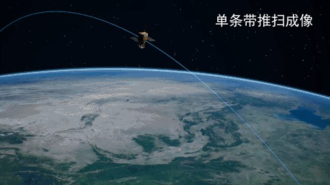
Operating at an altitude of 500 kilometers in a sun-synchronous orbit, SuperView Neo-1 03 and 04 feature ultra-high-resolution imaging, ultra-agile control, and exceptional positioning accuracy, achieving performance levels that meet international standards for commercial satellites. For ultra-high-resolution imaging, the satellites employ a unique "dynamic-static separation" dual-ultra technology developed by SAST, utilizing a large-aperture optical camera magnetically suspended above the satellite platform. This setup allows for ultra-precise and ultra-stable high resolution “vibration-free imaging," providing the highest imaging resolution among domestic commercial remote sensing satellites—a true “eagle eye” in space with precise targeting and crystal-clear vision. In terms of ultra-agile control, these satellites are the first to apply dual-ultra agile control technology in orbit. They support diverse imaging modes, including push-broom imaging, multi-point agile imaging, multi-band mosaic imaging, 3D imaging, and curved trajectory imaging, enabling quick responses to varied user needs. They are truly versatile tools for space-based remote sensing. Regarding positioning accuracy, the satellites pioneer the use of angle monitoring technology in China's commercial remote sensing sector, establishing a precision "angle meter" with sub-arcsecond accuracy between the cameras pointing and the platform attitude reference. This system enables real-time in-orbit monitoring of micro-scale changes caused by spatial thermal deformation, resulting in image positioning accuracy within 5 meters without ground control points—a true benchmark for global commercial satellites.
Upon entering orbit, the SuperView Neo-1 03 and 04 satellites will acquire ultra-high-resolution, high-precision visible-light satellite data globally, with stereo mapping capabilities. These satellites will serve diverse sectors such as natural resource management, urban planning, and emergency response, offering rich data products and versatile application services. Their advanced capabilities position them for expansive market potential and application both domestically and internationally. Once the commercial satellite system is fully operational, it will deliver faster, more efficient, high-precision, high-revisit-rate, and wide-coverage remote sensing data services, establishing world-class data acquisition and commercial operational capabilities.
Throughout the development process, the team consistently combined technological breakthroughs with management innovation, undertaking simultaneous development to secure the launch mission. By adopting a “parallel development and testing” model, they achieved short cycles, low costs, and high reliability through efficient iteration and uniform technological standards. This methodology provided extensive research experience in the effective development and large-scale production of commercial satellites. Rigorous control processes were established to scrutinize key aspects, with electronic quality control implemented for all records and test data. Critical elements, such as the satellite polarity, launch site testing, and integrated operations, underwent thorough verification, while flight procedures and troubleshooting plans were continuously refined to lay a solid foundation for the successful launch and stable operation of the satellites in orbit.

Spaceflight